
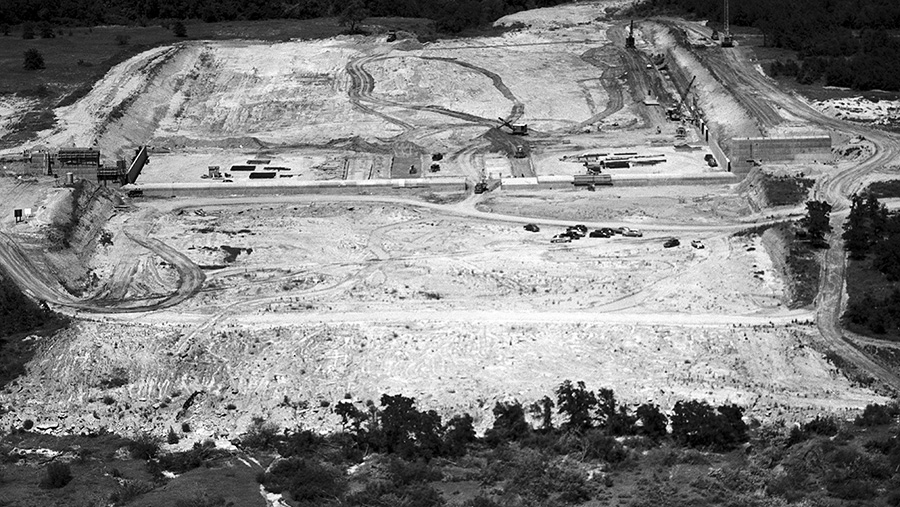
In this 1950 U.S. Army Corps of Engineers photo, the viewer is looking east, downstream of the spillway. The buildup on the right is the Corps observation area. Driving along Fairway Drive today, one can see either side with rails where staff can stand to make observations of the spillway and water levels. These areas are no longer open to the public. Photo by U.S. Army Corps of Engineers and courtesy of Southlake Historical Society
Why Lake Grapevine is so important to Southlake’s history
By Tori Couch
Southlake Historical Society’s annual summer exhibit highlights the link between Lake Grapevine and Southlake’s origins
Imagine packing the car after church, driving onto the spillway of an under-construction dam, pulling out a picnic and taking in the surrounding sights with no phones or modern-day distractions. Or heading out for a fishing expedition after the lake was built.
These pastimes were a reality for many people living near what is now known as Lake Grapevine in the 1950s and ’60s. The lake also spurred the incorporation of Southlake in 1956.
The history behind those memories, the lake’s creation and Southlake’s beginnings will be on display through Aug. 24 at the Southlake Historical Society’s 10th annual summer exhibit. This year’s exhibit — “Making a Splash: How Lake Grapevine Put Southlake on the Map” — is inside Southlake Town Hall.
“We knew we were going to do Lake Grapevine because it’s important to the area and Southlake, because Southlake was named for being south of the lake,” Connie Cooley, Southlake Historical Society president, said. “So, that was a perfect connection.”
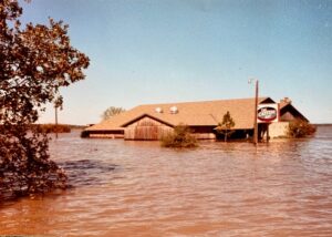
The 1981 Great Flood caused Lake Grapevine to register a record-setting 563.5 feet. Homes and lakeside businesses, such as The Catfish Hut local favorite, were underwater for up to three weeks. The Catfish Hut later became Paradise Cove at Lake Grapevine and operates today as an event venue.
Photo courtesy of Southlake Historical Society
The U.S. Army Corps of Engineers constructed Lake Grapevine and the dam between 1947-1952 to help control flooding from the Trinity River and provide water for Dallas. More than 15,000 acres of Denton Creek bottomlands were cleared for the project, with the lake covering 6,700 acres.
Using modern landmarks, the lake runs east and west, from Grapevine Mills Mall to Texas Motor Speedway, while the dam covers a north-to-south stretch from the Grapevine-Flower Mound border to the Gaylord Texan Resort and Great Wolf Lodge.
Even though Southlake, Grapevine and the surrounding cities have changed over the years, the lake still provides water for Grapevine, Dallas and Park Cities and plenty of recreational activities.
John Mathney, Lake Grapevine’s manager for the Corps of Engineers, grew up in Colleyville and attended Grapevine High School in the mid-90s. He recalls swimming in the lake, spending time there with his dad and brothers, and taking a few boating lessons.
“I learned the value of checking the boat before you launch it because we launched, and we sure did not put that plug in the boat,” he said.
Mathney joined the Army Corps of Engineers in 2008, working in Lewisville. He came to Grapevine as the lead park ranger eight and half years later and took over the manager post in late 2020.
Activities enjoyed on the lake have evolved over the years, Mathney noted, with people doing everything from slalom skiing to water skiing and wake surfing. Fishing from boats, and even kayaks, remains popular, too.
Flooding remains a concern today. Since the 1950s, the area has endured five floods, including two major ones in 1981 and 2015. Both floods were at least 3 feet over the spillway, which sits at 560 feet above sea level, Mathney said. The lake’s normal elevation is 535 feet above sea level.
In the ’40s, flooding hurt the farmers who called Denton Creek home.
“Most people were farmers and it was really important to try to keep the waters from flooding,” Cooley said. “So, that’s really what kickstarted the location for Lake Grapevine.”
Building the lake and dam might have taken about a half-decade, but getting the green light took much longer. Conversations surrounding a water resource in the area date to at least 1919 based on the research conducted by Grapevine Public Library’s genealogy librarian, Nancy Maxwell.
Maxwell spent 2023 researching the lake’s origin’s for the library’s blog. By looking through Fort Worth and Dallas newspaper archives, she also learned about a canal project proposed by John Carpenter and Amon G. Carter Sr. that would run water from North Texas to the Gulf of Mexico. The canal ultimately fell through and was a separate venture from the needs surrounding Denton Creek, but it showed how wide-reaching water issues were at the time.
A couple decades passed before funding came through for Lake Grapevine and the dam. It required trips to Washington, D.C., and monetary commitments from the federal government and surrounding cities.
“It was absolutely fascinating how I could see this developing over time and, most interestingly, to see the individuals involved and the stakes that they had and their personal efforts to bring this about,” Maxwell said. “The lake didn’t just appear. It took decades of people fighting on both sides of the congressional aisle to get it going.”
Maxwell found countless nuggets of information that add more color and insight to the portion of the exhibit dedicated to those early days. During the research process, she even found a photo of Carpenter, Carter and the head of the Corps of Engineers with a specially crafted three-headed shovel colored red, white and blue at the dam’s groundbreaking.
Of course, the city of Southlake got its start in large part because of the lake. As the lake brought in more people and commerce, some of the surrounding cities, including Hurst, wanted to annex the area. The families in what is now Southlake voted to become incorporated in 1956, sparking growth. Dallas Fort Worth International Airport’s opening in 1974 fueled that trend even more.
Not everyone loved the introduction of Lake Grapevine, including Grapevine’s mayor, Benjamin Richard Wall. He sent a letter to Congress while the Texas delegation was there stating his opposition to the dam.
“He just didn’t think it was practical,” Maxwell said. “He didn’t think it was right that so many hard-working, fine pioneer families were going to lose their land if they couldn’t relocate it. A lot of them couldn’t.”
Maxwell found at least 30 instances of people being compensated for loss of land.
“That’s by no means complete,” she said. “I’m sure there were many more.”
The exhibit will feature historical photos from several sources, including the historical society’s archives and Maxwell’s research. Mathney also supplied some photos and helped identify where photos were taken on the lake.
Included in the exhibit’s photos are pictures of fossils, dinosaur tracks and caves found as the lake receded over the years. Another item discovered during a water recession in the mid-2010s was a machine used during the lake’s construction.
At the time, Mathney was in Lewisville and helped the Grapevine park ranger reattach a buoy to the machine. The machine’s top had been cut off before the ’81 flood when the lake was low, but the rest remained in the water.
“It was there when they were building the dam, and then I think they expected it to take X amount of years to fill up,” Mathney said. “And then it filled up so quickly. They got everything out, except that it was such a big piece of machinery, they never could go back in there to get it.”
The exhibit will focus mainly on Lake Grapevine’s early days and activities that took place there in the 1960s and ’70s, but will connect to the present day.
“We just try to bring it forward to where we are now,” Cooley said.